Smoke from nearby forest fires continued to obscure views and caused us to smell smoke pretty much all the time.


In addition to all the chainsaw statues carved from wood, on my early morning walk I have discovered that there are numerous murals painted on buildings.

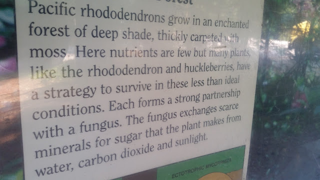
The goal for Wednesday was to go south east on BC Route 3 to E.C. Manning Provincial Park. Our goal was to hike the Lightening Lake Loop Trail, but on the way there, we passed Rhododendren Flats and walked the short, 500 meter loop trail after learning about some the things being done by the park service.


Many rhododendrons but the flowers are all gone.


Our next stop was the E.C. Manning Visitor Center. Among other things, they had snow shoes like we had back in the 1970s. They also confirmed the info we had about the Lightening Lake Loop Trail.


And they had photos of past bird sightings in the park.

We then set off for Lightening Lake. It is part of a series of four connected lakes, Lightening, Flash, Strike and Thunder. The loop around Lightening was described as 9 kms and about 3 hours hiking time. It starts at one end of the long and narrow lake, where they have canoe and kayak rentals, and many people enjoying the lake.


There were also a lot of these rodents who appeared to me to be cousins of prairie dogs.


We continued around the lake where there were ducks and loons.


As always, Canadian parks have good signage and marking of trails.

The trails are easy to follow and quite picturesque.


We finally came to the Lightening Creek bridge which separates Lightening Lake from Flash Lake.


As we continued back on the other side of the lake, we observed that the hills had very steep sides, steeper than 45 degrees, more like 60 degrees - we saw many rock slides.


Also many fallen trees.


We passed by a beaver lodge on the side of the lake.


We finally got back to a section just across the lake from where we started.


After about three hours, we had covered about seven miles. We then went for a very nice late lunch around 3:00 at the Cascade Cafe at the Manning Lodge - burger, fries and a Corona for Patty, veggie burger, chicken soup and Diet Coke for me.
While on our lake loop hike, we met a couple of women from outside Vancouver who told us about the sub-alpine meadows on Blackwall Peak. So after lunch, we set out for Blackwall Peak. It was 15 miles of continuous uphill driving on a narrow and curvy road with virtually no guard rails or retaining walls. That said, the road was in very good shape and not overly steep. We soon learned this was because of the large microwave tower at the top of the mountain at some 2,000 meters elevation. Once there, we decided to hike the Paintbrush Trail, a loop that goes around the microwave tower but goes through some beautiful meadows of wildflowers and provides amazing views of the snow covered mountains around there.


We learned about how the Cascades Recreation Area recently became part of E.C. Manning Provincial Park.


Another great day exploring this part of British Columbia.


In addition to all the chainsaw statues carved from wood, on my early morning walk I have discovered that there are numerous murals painted on buildings.

The goal for Wednesday was to go south east on BC Route 3 to E.C. Manning Provincial Park. Our goal was to hike the Lightening Lake Loop Trail, but on the way there, we passed Rhododendren Flats and walked the short, 500 meter loop trail after learning about some the things being done by the park service.


Many rhododendrons but the flowers are all gone.


Our next stop was the E.C. Manning Visitor Center. Among other things, they had snow shoes like we had back in the 1970s. They also confirmed the info we had about the Lightening Lake Loop Trail.


And they had photos of past bird sightings in the park.

We then set off for Lightening Lake. It is part of a series of four connected lakes, Lightening, Flash, Strike and Thunder. The loop around Lightening was described as 9 kms and about 3 hours hiking time. It starts at one end of the long and narrow lake, where they have canoe and kayak rentals, and many people enjoying the lake.


There were also a lot of these rodents who appeared to me to be cousins of prairie dogs.


We continued around the lake where there were ducks and loons.


As always, Canadian parks have good signage and marking of trails.

The trails are easy to follow and quite picturesque.


We finally came to the Lightening Creek bridge which separates Lightening Lake from Flash Lake.


As we continued back on the other side of the lake, we observed that the hills had very steep sides, steeper than 45 degrees, more like 60 degrees - we saw many rock slides.


Also many fallen trees.


We passed by a beaver lodge on the side of the lake.


We finally got back to a section just across the lake from where we started.


After about three hours, we had covered about seven miles. We then went for a very nice late lunch around 3:00 at the Cascade Cafe at the Manning Lodge - burger, fries and a Corona for Patty, veggie burger, chicken soup and Diet Coke for me.
While on our lake loop hike, we met a couple of women from outside Vancouver who told us about the sub-alpine meadows on Blackwall Peak. So after lunch, we set out for Blackwall Peak. It was 15 miles of continuous uphill driving on a narrow and curvy road with virtually no guard rails or retaining walls. That said, the road was in very good shape and not overly steep. We soon learned this was because of the large microwave tower at the top of the mountain at some 2,000 meters elevation. Once there, we decided to hike the Paintbrush Trail, a loop that goes around the microwave tower but goes through some beautiful meadows of wildflowers and provides amazing views of the snow covered mountains around there.


We learned about how the Cascades Recreation Area recently became part of E.C. Manning Provincial Park.


After the long drive back down the mountain, we headed back to Hope. Along the way, we stopped at the Hope Slide - the site of a large landslide in 1965. Click on this link for more info about the Hope Slide.


Another great day exploring this part of British Columbia.
No comments:
Post a Comment