In the Sunday paper, there was an article about a new section of trail being opened. The Historic Scenic Columbia Gorge Highway 30 was built in the early 1900s as a majestic and beautiful drive through the Columbia Gorge. By 1922, it was finished and was both an engineering marvel and a beautiful drive. Unfortunately, when I-84 was built in the 1950s and 60s, there was only limited space between the Columbia River and the rock cliffs of the Columbia Gorge. To have room for both the railroad tracks and the new four lane interstate highway, sections of the scenic Highway 30 were destroyed. Fortunately, the western half of the original scenic highway has been maintained for driving - and now the eastern portion is being redeveloped to have paved biking/hiking paths with a goal of a continuous paved path separate from the highway all the way from Portland to Hood River. Sunday we went to explore this newly completed section, described in the paper as starting at Starvation Creek State Park and heading east. So we started our hike on this rainy Sunday at Starvation Creek State Park.
Starvation Creek got its name from 1885 when the westward bound train came around the corner and was confronted by a 25 foot snow drift. Although no one starved, it took three weeks for the train to finally arrive at its scheduled stop in Portland.


The article in the Sunday paper indicated that we would see three waterfalls, so we were pleased to see this first one only a few hundred yards on the trail.


Initially, I only saw this smaller lower part of the falls that Patty posed by for photos. Only when leaving there did I turn around and see the rest of the waterfall, several hundred feet tall.


After seeing the first waterfall and learning about the history of Starvation Creek and the three weeks spent there by the train in 1885, we continued east as described in the newspaper. Much to our surprise, the very nice trail did not appear to show any new construction. We later determined that the article in the paper incorrectly said east (which was were we were going) when it should have said west. Nonetheless, it was a delightful trail with great foliage and views - and it was paved, so hiking in the rain was not a problem.


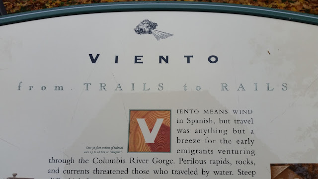
We got to the end of this section and found ourselves at Viento State Park, so we explored that park. There was a tent campground on the south side of the highway but no campers there. So we followed the road under the interstate highway to the north part of the park where there were RV camping sites available - we did not walk through that part, but did see a couple of cars.


This is looking west on the river.


This is looking east.

This is looking north across the river.

And this is looking south back into the park.

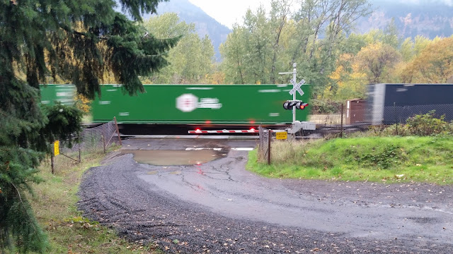
Besides going under the interstate highway, we also had to cross active railroad tracks. On the way back, we literally were two steps from the having stepped over the tracks when the alarms went off, the lights started flashing, the arms came down and the oncoming train started blowing its horn.
After returning to our car, we drove east about 15 miles and had lunch at 6th Street Bistro in Hood River. We contemplated returning to Starvation Creek State Park and heading west on the new part of the trail, but by then, the rain had changed from light and sporadic showers to a fairly heavy, consistent downpour - so we decided not to hike further.
We continued west towards Portland but made a brief stop at Rooster Rock State Park. It is massive - probably more than 500 parking spaces. It is named for a large phallic shaped rock. We read online that the native term for the rock translate as penis and the original name was Cock Rock but was changed to Rooster Rock to avoid offending the sensibilities of some people (political correctness run amok). And we also learned that it was the first of two sanctioned clothing optional beaches in the state of Oregon - but on a cool, rainy day, there was hardly anyone in the park.
Starvation Creek got its name from 1885 when the westward bound train came around the corner and was confronted by a 25 foot snow drift. Although no one starved, it took three weeks for the train to finally arrive at its scheduled stop in Portland.


The article in the Sunday paper indicated that we would see three waterfalls, so we were pleased to see this first one only a few hundred yards on the trail.


Initially, I only saw this smaller lower part of the falls that Patty posed by for photos. Only when leaving there did I turn around and see the rest of the waterfall, several hundred feet tall.


After seeing the first waterfall and learning about the history of Starvation Creek and the three weeks spent there by the train in 1885, we continued east as described in the newspaper. Much to our surprise, the very nice trail did not appear to show any new construction. We later determined that the article in the paper incorrectly said east (which was were we were going) when it should have said west. Nonetheless, it was a delightful trail with great foliage and views - and it was paved, so hiking in the rain was not a problem.


We got to the end of this section and found ourselves at Viento State Park, so we explored that park. There was a tent campground on the south side of the highway but no campers there. So we followed the road under the interstate highway to the north part of the park where there were RV camping sites available - we did not walk through that part, but did see a couple of cars.


After taking a few minutes to read about the park, we then followed a trail down to the Columbia River.


This is looking west on the river.


This is looking east.

This is looking north across the river.

And this is looking south back into the park.

Besides going under the interstate highway, we also had to cross active railroad tracks. On the way back, we literally were two steps from the having stepped over the tracks when the alarms went off, the lights started flashing, the arms came down and the oncoming train started blowing its horn.

After returning to our car, we drove east about 15 miles and had lunch at 6th Street Bistro in Hood River. We contemplated returning to Starvation Creek State Park and heading west on the new part of the trail, but by then, the rain had changed from light and sporadic showers to a fairly heavy, consistent downpour - so we decided not to hike further.
We continued west towards Portland but made a brief stop at Rooster Rock State Park. It is massive - probably more than 500 parking spaces. It is named for a large phallic shaped rock. We read online that the native term for the rock translate as penis and the original name was Cock Rock but was changed to Rooster Rock to avoid offending the sensibilities of some people (political correctness run amok). And we also learned that it was the first of two sanctioned clothing optional beaches in the state of Oregon - but on a cool, rainy day, there was hardly anyone in the park.


